๐ŸŒ Worldwide shipping ยท 30-day returns ยท Rated Excellent on Trustpilot โ˜…โ˜…โ˜…โ˜…ยฝ
Price
$62.99
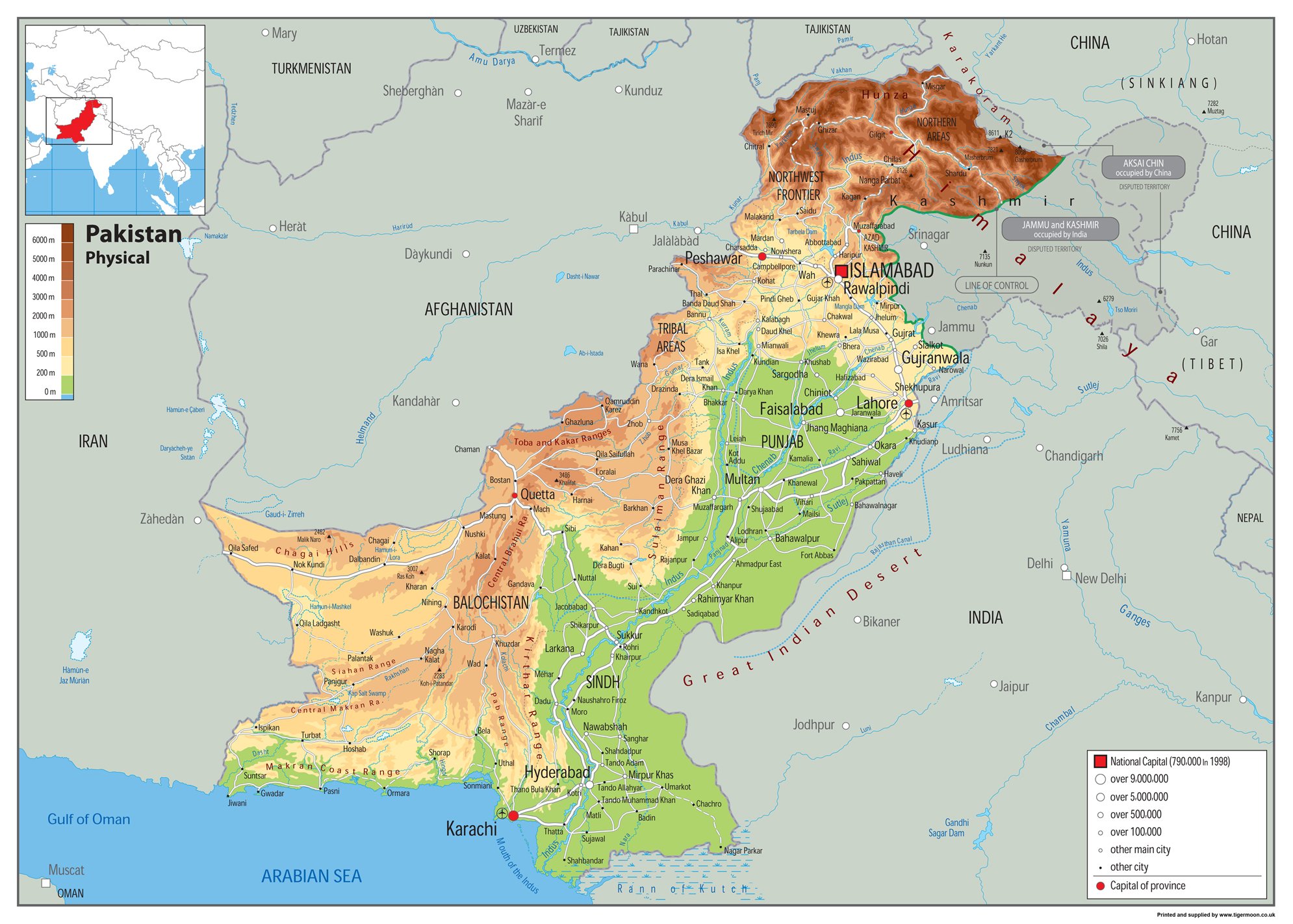
Physical Map of Pakistan - Size A1-59.4 x 84.1cm - Paper Laminated โ€” image 1
Educational Charts & PostersTiger Moon The Tiger Moon Trading Company Ltdโœ“ In stock

Physical Map of Pakistan - Size A1-59.4 x 84.1cm - Paper Laminated

โ˜…โ˜…โ˜…โ˜…โ˜…
$62.99
Worldwide shipping
Fast tracked delivery
30-day returns
Hassle-free returns
Secure checkout
Safe & protected
Great service
Thousands of happy customers
Add to cart
About this item
  • Pakistan, known as the Islamic Republic of Pakistan, stands as a sovereign nation in South Asia. With a population of over 241.5 million, it ranks as the fifth-most populous country and boasts the second-largest Muslim population as of 2023. Islamabad serves as its capital, while Karachi reigns as its largest city and financial hub.
  • Bordered by the Arabian Sea, the Gulf of Oman, and the Sir Creek on its southern, southwest, and southeast sides, it shares land borders with India, Afghanistan, Iran, and China. Its maritime border adjoins Oman in the Gulf of Oman, and its northwestern border with Tajikistan is separated by Afghanistan's narrow Wakhan Corridor.
  • Our Physical Map of Pakistan is vibrant and informative, with easy-to-read text and bright colours. Including capital cities, rivers, major roadways, towns, surrounding bodies of water and mountain ranges. The physical aspects such as land elevation are clearly showed and makes for an attractive map either for the home, office or school, for display on a wall or for desk work.
  • Size A1 - 59.4 x 84.1 cm. Printed onto high quality poster paper and laminated for durability.
Product description

Pakistan, known as the Islamic Republic of Pakistan, stands as a sovereign nation in South Asia. With a population of over 241.5 million, it ranks as the fifth-most populous country and boasts the second-largest Muslim population as of 2023. Islamabad serves as its capital, while Karachi reigns as its largest city and financial hub. Bordered by the Arabian Sea, the Gulf of Oman, and the Sir Creek on its southern, southwest, and southeast sides, it shares land borders with India, Afghanistan, Iran, and China. Its maritime border adjoins Oman in the Gulf of Oman, and its northwestern border with Tajikistan is separated by Afghanistan's narrow Wakhan Corridor. Our Physical Map of Pakistan is vibrant and informative, with easy-to-read text and bright colours. Including capital cities, rivers, major roadways, towns, surrounding bodies of water and mountain ranges. The physical aspects such as land elevation are clearly showed and makes for an attractive map either for the home, office or school, for display on a wall or for desk work. Size A1 - 59.4 x 84.1 cm. Printed onto high quality poster paper and laminated for durability.

Product details
Brand
Tiger Moon The Tiger Moon Trading Company Ltd
Manufacturer
Tiger Moon
Colour
Clear
Size
A1 Size 59.4 x 84.1 cm
EAN
0638845177238

Customer reviews

What customers say about Bigamart

10 Trustpilot reviews total, with 2 shown at a time.

Trustpilot
โ˜…โ˜…โ˜…โ˜…โ˜…
Excellent
4.5 average rating
See all reviews โ†’
S
Sigalit
๐Ÿ‡ฎ๐Ÿ‡ฑ ยท January 2026
โ˜…โ˜…โ˜…โ˜…โ˜…

I wrote to Bigamart's customer support and they accompanied the process of reshipping the item until it finally arrived. I felt a genuine effort to solve the problem till it was finally solved.

V
Verified buyer
๐Ÿ‡ฆ๐Ÿ‡บ ยท November 2025
โ˜…โ˜…โ˜…โ˜…โ˜…

The package was here in Australia from England in a few days โ€” so quick! Something was missing and they refunded it straight away. Pretty happy with these guys.

Showing 1โ€“2 of 10 reviews

You might also like

Similar items

View all โ†’
Physical Map of Pakistan - Size A1-59.4 x 84.1cm - Paper Laminated | Bigamart