๐ŸŒ Worldwide shipping ยท 30-day returns ยท Rated Excellent on Trustpilot โ˜…โ˜…โ˜…โ˜…ยฝ
Price
$135.99
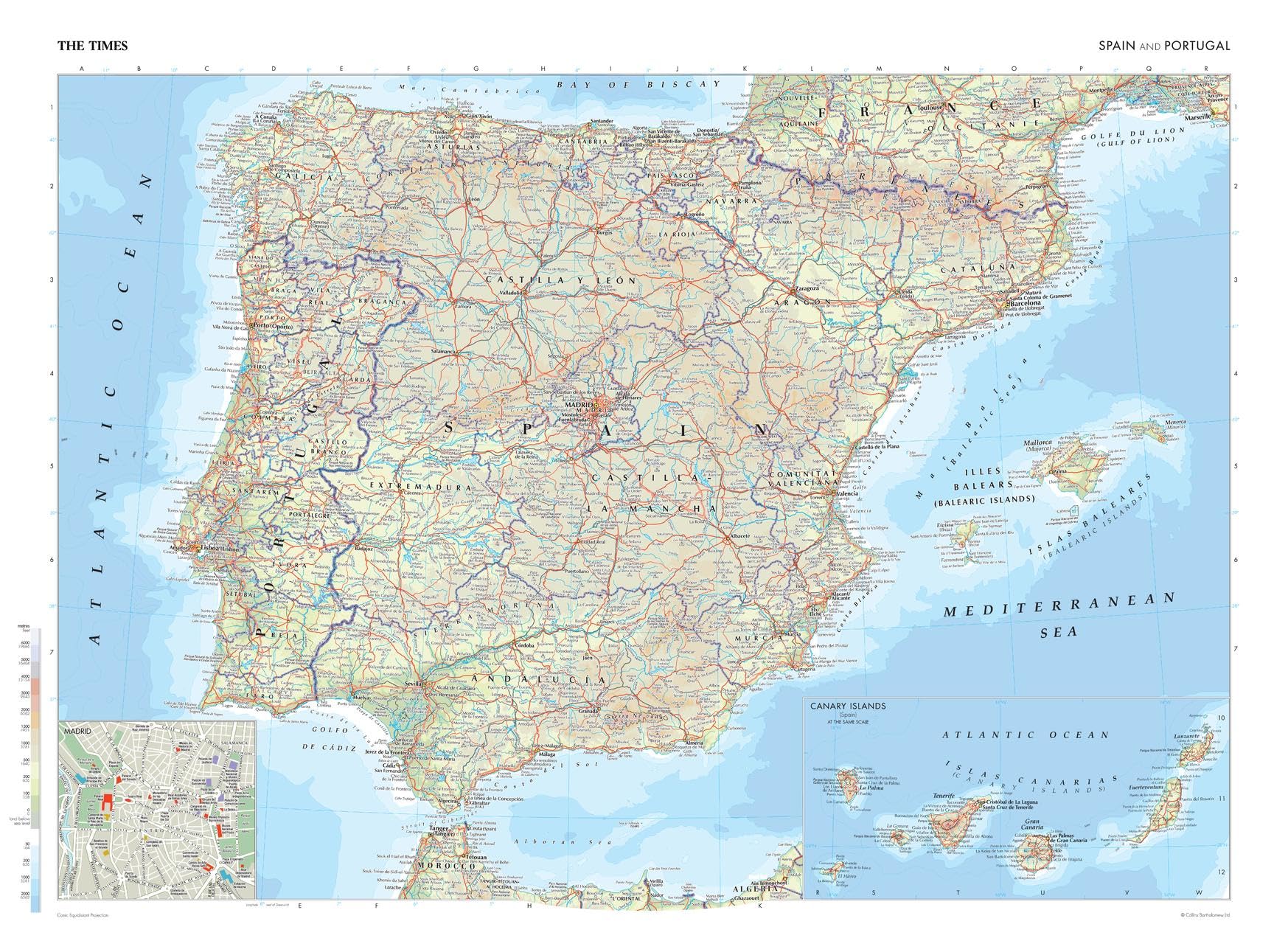
The Times Atlas: Spain and Portugal - 92 x 67 cm Poster - Front Lamination โ€” image 1
Educational Charts & PostersMapSherpaโœ“ In stock

The Times Atlas: Spain and Portugal - 92 x 67 cm Poster - Front Lamination

โ˜…โ˜…โ˜…โ˜…โ˜…
$135.99
Worldwide shipping
Fast tracked delivery
30-day returns
Hassle-free returns
Secure checkout
Safe & protected
Great service
Thousands of happy customers
Add to cart
About this item
  • TRUSTED PUBLISHER: The Times are a world leader in the publishing industry and are one of the most recognizable brands around the globe. This map is taken from The Times Comprehensive Atlas of the World, which is regarded as the worldโ€™s most prestigious and authoritative source of atlases and maps.
  • STYLISH CARTOGRAPHY: These beautiful natural colors help to highlight the physical features, making this perfect a perfect look for the classroom, home or boardroom.
  • MAJOR FEATURES: Map details include detailed road and highway networks, international borders, water depth, distance above/below sea level, and more!
  • HIGH QUALITY PRINT: Your laminated map has a glossy finish so that you can use dry erase markers on the map to highlight features, make plans, and share unique information with others. Lamination is also extremely durable, resistant to folding or ripping. Your map is rolled and packaged in a sturdy tube to protect it during shipment.
  • ROLLED IN A STURDY TUBE: Your map is rolled and packaged in a sturdy tube to protect it during shipment
Product description

This map of Spain and Portugal is a benchmark of cartographic excellence, taken from the industry leading Times Comprehensive Atlas of the World. There is a high level of detail packed into the map, yet the positioning of every element is carefully chosen to make the map coherent and attractive. Major cities including Barcelona, Porto and Sevilla are easily identifiable, as are the capitals of Madrid and Lisbon. International borders are clearly marked as are regional boundaries within both countries. Geographical features such as the Pyrenees Mountain range are clearly marked. Additional inset maps provide further detailing of the Canary Islands and a road map of Madrid. Page Size: 36.5 x 26.75 in (924 x 675 mm) Your laminated map has a glossy finish so that you can use dry erase markers on the map to highlight features, make plans, and share unique information with others. Lamination is also extremely durable, resistant to folding or ripping. Your map is rolled and packaged in a sturdy tube to protect it during shipment.

Product details
Brand
MapSherpa
Colour
Multi
Part number
697942196481
EAN
0697942196481

Customer reviews

What customers say about Bigamart

10 Trustpilot reviews total, with 2 shown at a time.

Trustpilot
โ˜…โ˜…โ˜…โ˜…โ˜…
Excellent
4.5 average rating
See all reviews โ†’
S
Sigalit
๐Ÿ‡ฎ๐Ÿ‡ฑ ยท January 2026
โ˜…โ˜…โ˜…โ˜…โ˜…

I wrote to Bigamart's customer support and they accompanied the process of reshipping the item until it finally arrived. I felt a genuine effort to solve the problem till it was finally solved.

V
Verified buyer
๐Ÿ‡ฆ๐Ÿ‡บ ยท November 2025
โ˜…โ˜…โ˜…โ˜…โ˜…

The package was here in Australia from England in a few days โ€” so quick! Something was missing and they refunded it straight away. Pretty happy with these guys.

Showing 1โ€“2 of 10 reviews

You might also like

Similar items

View all โ†’
The Times Atlas: Spain and Portugal - 92 x 67 cm Poster - Front Lamination | Bigamart